Map of Bolivia.
|
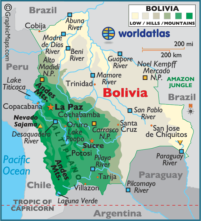
Bolivia is a country located in South America with a population of roughly 9,000,000 people. Its surrounding countries are Paraguay, Brazil, Peru, Chile, and Argentina. Some of the major cities in Bolivia are the following: Santa Cruz, Cochabamba, Oruro, and Potosi. Bolivia was once twice its size, stretching out to the Pacific Ocean, however Bolivia lost this area when there was a war with Chile in the year 1879. It is now one of two exclusively landlocked countries within both North and South America, Paraguay being the other. Today, Bolivia cannot have entry to go to either the Atlantic Ocean or the Pacific Ocean. There are two capital cities in Bolivia: La Paz and Sucre. LaPaz is located at 16.712° S and 64.666° W and is the highest capital city in altitude in the world at 12,001 feet above sea level or approximately 2.5 miles.
Type of Government Bolivia’s form of government is a republic with Evo Morales serving as the current president. Bolivia has a constitution and three branches of government: executive, legislative, and judicial. The executive branch of the government is located in La Paz. The president has a cabinet with ministers to assist in running the country. Bolivia’s second branch of government, the legislative branch, is the national congress which has a chamber with deputies and a chamber with senators. Bolivia’s third branch of government, the judicial branch, is the judiciary or supreme court which is located in Sucre. Geography and Climate Since Bolivia is located south of the equator, its seasons are reverse of those in the Northern Hemisphere with summer beginning in December and winter beginning in June. Its geography is as diverse as its climate. The valleys, the lowlands, and the Altiplano or High Plateau are Bolivia’s 3 main geographic regions. The Andes Mountains, the main mountain range in South America, splits into two ranges in Bolivia: the Cordillera Occidental and Cordillera Oriental. The peaks of the mountains are always snow-topped and contain the three highest mountain peaks in the world: Nevado Sajama, Mount Illampu, and Mount Illimani. The Beni and Mamore rivers collect the water from the melting snow in the mountains. These two rivers feed into the Madeira River, which is a tributary of the Amazon River. The Altiplano is the plateau located between the two mountain ranges and is about 2.5 miles above sea level. Because of the high altitude, it is very cold at night with frost developing, and it is very windy. On average, the temperature in the Altiplano is 47℉. Almost 50% of Bolivia’s population lives in the Altiplano. Lake Titicaca, the 2nd largest lake within South America, is also located in the Altiplano. Also located in the Altiplano in the southwest is the Salar de Uyuni, or the salt flats. Approximately 40,000 years ago this area was a significantly large prehistoric lake. The salt desert, which covers 4,674 square miles, was left behind when the lake dried up. The second main geographic region of Bolivia is the lowlands, also referred to as the Yungas. The Yungas are the deep valleys that are covered with plush green vegetation. Some areas cannot be accessed, but some valleys contain very fertile land where a wide range of fruit and vegetables can be grown. Almost half of the farmed land in Bolivia is in the Yungas region where 30 percent of the population lives. On average, the temperature in the lowlands is 80℉. The third main geographic region of Bolivia is the lowlands plain. The lowlands region, called the Oriente, covers 70% of Bolivia and is divided into three regions. The northern region contains part of the Amazon rain forest, wetlands, lagoons, river forests, and marshes. The eastern region and southern region contain dry forests and grasslands. The southern part of the lowlands is called the Chaco, and its climate is a semidesert for about eight months, which turns into a swamp when the rains arrive. The temperatures commonly reach 100 ℉ during the rainy season. |
